Download our Antenna Buyer’s Guide Today

Download our Antenna Buyer's Guide to discover the essential specs and features to look out for while finding the perfect antenna for your project.

Search with confidence and efficiency.
tab-img

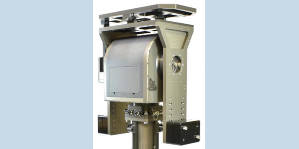
LinkAlign-360MPT-43 — Auto Acquisition and Program Tracking Satellite Positioner

Interested in learning more about this product?

Overview

The LinkAlign-360MPT-43 is an auto-acquisition satellite positioner designed to automatically point directional antennas for communications. Featuring an embedded controller with a built-in GPS and digital compass, this unit supports rapid, accurate pointing and Two-Line Element (TLE) program tracking for LEO and MEO satellites. It simplifies system integration with Power over Ethernet (PoE) operation and multiple pass-thru connections.

Technical Summary

  • Payload Capacity: Up to 160 lbs (72.6 kg)
  • Azimuth Travel: 480° continuous
  • Elevation Travel: Up to 190°
  • RF Pass-Thrus: Dual N-type, rated DC-3 GHz
  • Data Pass-Thru: 1 Gbps Ethernet
  • Operation: Power over Ethernet (PoE)

Operational Use Cases

This positioner is engineered for satellite communications, specifically targeting low or medium earth orbit (LEO/MEO) satellites. It is well-suited for automated program tracking, satellite database management, and applications requiring precise, automated directional antenna pointing.

Performance Metrics

  • Maximum Payload: 160 lbs (72.6 kg)
  • RF Frequency Range: DC to 3 GHz
  • Ethernet Throughput: 1 Gbps
  • Axis Travel: 480° Azimuth / 190° Elevation

Setup & Portability

The system operates on Power over Ethernet (PoE), streamlining power and data cable routing. It is controlled via a full-featured web-based user interface or a command line interface (CLI) for system integration. An optional cross-elevation accessory can be installed to eliminate the keyhole effect during overhead satellite passes.

Compatibility

The LinkAlign-360MPT-43 is typically paired with 3-4 ft antennas. It features dual N-type connectors for DC-3 GHz RF routing and supports 1 Gbps Ethernet connections.

FAQs

  • What is Two-Line Element (TLE) tracking used for in satellite positioners? TLE sets provide orbital data used to compute the trajectory of a satellite. Positioners utilize this data for automatic program tracking of targets in low or medium earth orbit (LEO/MEO).
  • How does a cross-elevation accessory improve overhead satellite tracking? Standard azimuth-elevation mounts can struggle to track targets passing directly overhead, known as the keyhole effect. Adding a cross-elevation accessory enables continuous tracking during these passes to maintain the communication link.
  • What role does an embedded controller play in antenna pointing? Embedded controllers communicate with onboard sensors like GPS and digital compasses to calculate orientation. This enables positioner software to automate acquiring, pointing, and maintaining communication links.
  • Problems we solve: where do we start with incomplete requirements? An incomplete specification can make product selection difficult. Start by sharing the task, operating environment and known constraints with Cyntony so the team can help define what to verify and which options are worth discussing (Our process).
  • Outcomes we deliver: what comes from working through the requirements? The practical outcome is a requirements-led set of product options to evaluate with Cyntony. Confirm performance, compatibility and any service scope for your configuration before selection (Our process).

Video Notes

A video demonstrating the web-based UI during a TLE tracking sequence or showcasing the optional cross-elevation accessory eliminating the keyhole effect would be highly beneficial.

HOW TO BUY
To obtain price and delivery information about this product, click the button below.