Download our Antenna Buyer’s Guide Today

Download our Antenna Buyer's Guide to discover the essential specs and features to look out for while finding the perfect antenna for your project.

Search with confidence and efficiency.

tab-img

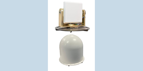
C360MPS-10 — LinkAlign- Maritime Microwave LOS Auto Tracking Antenna System

Interested in learning more about this product?

Overview

The LinkAlign-C360MPS-10 by Nextmove Technologies is a maritime microwave Line of Sight (LOS) auto-tracking antenna system and positioner. Designed to support ship-to-ship and ship-to-shore data links, it features an integrated 5 GHz antenna and an embedded controller equipped with a built-in GPS and digital compass to autonomously acquire and maintain communications.

Technical Summary

  • Frequency Band: C-Band (Integrated 5 GHz antenna)
  • Gain: 23.5 dBi
  • Positioner Travel: Continuous 360° azimuth, 110° elevation (-10° to +100°)
  • Feedback Resolution: 0.01°
  • Polarization: Dual
  • Control Interfaces: Web-based GUI, CLI, SNMP

Operational Use Cases

  • Ship-to-ship microwave communication links
  • Ship-to-shore data networks
  • Point-to-point and point-to-multipoint maritime networks

Deployment Environments

Engineered for maritime platforms, the system includes weather-tight connections for exposed deployments. It supports optional onboard gyro stabilization and can accept external pitch and roll telemetry from existing onboard sensor suites to maintain targeting during vessel movement.

Performance Metrics

  • Azimuth Range: Continuous 360°
  • Elevation Range: -10° to +100°
  • Position Feedback Resolution: 0.01°
  • Antenna Gain: 23.5 dBi

Setup & Portability

Configuration, monitoring, and acquisition are managed via a web-based interface or a command-line interface for complex system integrations. The unit utilizes weather-tight RJ-45 Power over Ethernet (PoE) connections for streamlined cabling.

Compatibility

The system operates seamlessly with commercial Radio and ODU solutions. It also interfaces with external maritime sensor suites to accept pitch and roll data.

FAQs

  • What is the benefit of integrating a GPS and digital compass in a tracking antenna? These sensors provide the baseline heading and location data required by the antenna controller to calculate its initial spatial orientation. This telemetry enables the system to autonomously acquire and actively track remote communication nodes.
  • How does a tracking positioner handle vessel movement during maritime deployment? Continuous tracking on maritime vessels requires stabilization against wave-induced pitch and roll. Verify that the selected positioner supports internal gyro stabilization or can interface with existing onboard sensor suites to compensate for movement.
  • Does a dual-polarized antenna provide broader angular coverage? Dual polarization describes the orientation of the electric fields for signal isolation, not the physical width of the radiation pattern. Verify the beamwidth specifications on the product datasheet to determine the actual angular coverage.
  • Problems we solve: where do we start with incomplete requirements? An incomplete specification can make product selection difficult. Start by sharing the task, operating environment and known constraints with Cyntony so the team can help define what to verify and which options are worth discussing (Our process).
  • Outcomes we deliver: what comes from working through the requirements? The practical outcome is a requirements-led set of product options to evaluate with Cyntony. Confirm performance, compatibility and any service scope for your configuration before selection (Our process).

Video Notes

Consider a video demonstrating the auto-acquisition process using the web-based tracking interface, alongside an overview of how the system processes pitch and roll compensation in a simulated maritime environment.

HOW TO BUY
To obtain price and delivery information about this product, click the button below.